Tag Archives: GIS

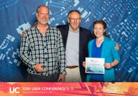
U-M receives Esri’s 2021 award for Geographic Information System

By | August 11, 2021

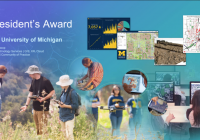
At this past July’s annual Esri User Conference, the University of Michigan was recognized with the prestigious President’s Award for being a model for the higher education community in how to become a true geospatial university. Receiving the award on behalf of the university, in front of a virtual audience of over 60,000, Peter Knoop, a senior programmer/analyst… Read More »

Collaborative learning projects connect staff, build skills during remote work

In February of 2020, just before Campus shifted to remote work, an interdisciplinary group formed to learn about creating web mapping applications using the ArcGIS API for JavaScript. The idea: work on a project that meets the needs of a researcher, but also provides an opportunity to share and grow knowledge across teams, in turn allowing us to… Read More »

Profiles in IT: Caitlin Dickinson—Mapping maven

Caitlin Dickinson, mapping expert LSA Technology Services, finds joy in learning and discovery, and in using tools to create maps that solve problems. In this MITN interview, she offers tips, tools, and best practices for researchers and fellow map enthusiasts.  Tell us about your role as a Geographic Information System (GIS) consultant at LSA.  I assist LSA faculty,… Read More »

U-M online mapping tool tracks climate change impacts in Michigan

By | December 5, 2019

Many cities and residents in Michigan have already begun to feel the effects of climate change.  Such changes can damage the environment and public health.  Trish Koman, a research investigator for the School of Public Health, and her colleagues have developed the Michigan Environmental Project, an online mapping tool designed to track climate change impacts in Michigan.  The new… Read More »

Dearborn hosts GIS Day Wednesday, Nov. 14

  GIS Day is a global event celebrating the use of Geographic Information Systems (GIS). It provides an international forum for users of GIS technology to demonstrate real-world applications that are making a difference in our society. At the University of Michigan you can join the celebration by attending UM-Dearborn’s GIS Day Event (8:30 a.m.–4:30 p.m., Wednesday, November 14.) Activities will… Read More »

Get high-resolution aerial imagery from Nearmap US

Ever needed higher-resolution aerial imagery than Google or ArcGIS basemaps offer? Or, more frequent historical imagery? Nearmap, for which the Library recently renewed university-wide access, meets both those goals for developed areas of the U.S. (Rural areas are not covered by this service.) Nearmap imagery has a resolution of less than 7.5cm (or <3-inches), as compared to the… Read More »

OpenStreetMap conference Oct. 5-7

State of the Map US 2018, the OpenStreetMap user conference, will be held in Detroit, MI on 5-7 October this year! OpenStreetMap is the wikipedia of maps, an open, collaboratively edited map used for everything from international disaster response to autonomous vehicles. You can see the data in Apple Maps, Snapchat, Uber, Lyft, and dozens of other tools we use every day. State of the Map is particularly… Read More »

LSA IT honored for special achievement in GIS

Esri, the global leader in spatial analytics, presented LSA IT with Esri’s Special Achievement in GIS (SAG) Award on July 11 at the annual Esri User Conference. Selected from over 300,000 eligible candidates, LSA IT received the award for its innovative application of mapping, data analytics, and thought leadership in higher-education research and teaching. The SAG Awards are meant… Read More »

U-M recognized as leader in GIS by Esri

Earlier this year U-M was invited to participate in the informal Esri Development Center (EDC) program. We join a small number of universities recognized as leaders in GIS teaching and research. While the EDC program was initially conceived with a focus on development in the traditional sense—coding and programming of geographic information system (GIS) solutions—U-M was identified as… Read More »

UM-Dearborn hosts GIS Day 2017

The fourth annual GIS Day event, held on November 15 on the UM-Dearborn campus, drew 270 participants. Students, faculty, and staff from the Dearborn and Ann Arbor campuses, as well as members of the community, used the opportunity to learn about GIS applications through 15 presentations, as well as from one-on-one meetings in an exhibit setting with representatives of… Read More »

Big Ten Geoportal

By | March 31, 2017

Scholars and researchers have a new way to find and compare geospatial data and maps: the Big Ten Academic Alliance Geoportal. “The ease of use is wonderful, but what’s really new and different here is a search that allows you to compare contemporary data to old maps,” said Mara Blake, spatial and numeric data librarian at the U-M… Read More »

Annual Esri academic site license renewed

March is the month when U-M’s Esri academic site license renews each year. This includes licensing for ArcGIS for Desktop, ArcGIS Pro, ArcGIS Online, CityEngine, and a wide variety of other Esri products. The university-wide concurrent license server has already been updated, however, users relying on annual single-use licensing will need to re-authorize their installations by the end of the… Read More »

GIS Day

By | November 1, 2016

Wednesday, November 19; 8:30 a.m.–4 p.m.; Kochoff Hall, University Center, U-M Dearborn; GIS Day is a global event celebrating the use of Geographic Information Systems (GIS). Locally, a GIS Day event at U-M Dearborn will provide students, faculty, staff, and the community with the opportunity to explore, share, and learn about the application of GIS to problems that… Read More »

Detroitography GIS Workshop

By | November 1, 2016

Wednesday, November 2; 2–4 p.m.; Institute for the Humanities, 202 South Thayer Building, Osterman Common Room; Alex Hill, founder of Detroitography (an organization whose focus is on democratizing map making and refocusing data for people-centered innovation) conducts a workshop on the Geographic Information System software he uses to turn the raw data into maps.