AI-enabled surveys with Survey123
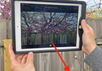
Automate data collection and improve data quality through the use of artificial intelligence models.

Automate data collection and improve data quality through the use of artificial intelligence models.
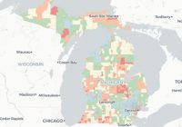
Many cities and residents in Michigan have already begun to feel the effects of climate change. Such changes can damage the environment and public health. Trish Koman, a research investigator for the School of Public Health, and her colleagues have developed the Michigan Environmental Project, an online mapping tool designed to track climate change impacts in Michigan. The new… Read More »

GIS Day is a global event celebrating the use of Geographic Information Systems (GIS). It provides an international forum for users of GIS technology to demonstrate real-world applications that are making a difference in our society. At the University of Michigan you can join the celebration by attending UM-Dearborn’s GIS Day Event (8:30 a.m.–4:30 p.m., Wednesday, November 14.) Activities will… Read More »

Ever needed higher-resolution aerial imagery than Google or ArcGIS basemaps offer? Or, more frequent historical imagery? Nearmap, for which the Library recently renewed university-wide access, meets both those goals for developed areas of the U.S. (Rural areas are not covered by this service.) Nearmap imagery has a resolution of less than 7.5cm (or <3-inches), as compared to the… Read More »