
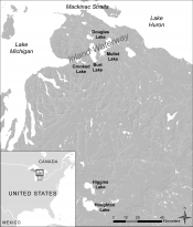
 Archaeologists in northern Michigan have used pulses of light shot from airplanes to double their discoveries. This remote sensing technology is called light detection and ranging, or lidar. Lidar sends out a pulse of light that returns a measure of distance from the object it strikes. It can greatly improve the efficiency of archaeological searches particularly when scanning vast areas for small details, according to a recent study. The work was supported by Jason Tallant, a data manager and research scientist with the U-M Biological Station near Pellston. Lidar was used at the station to look at the forest canopy and underlying land surface. (Story source: http://greatlakesecho.org/)
Related Posts